
Province of Paita topographic map
Interactive map
Click on the map to display elevation.
About this map
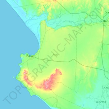
Name: Province of Paita topographic map, elevation, terrain.
Location: Province of Paita, Piura, 20701, Peru (-5.38846 -81.21197 -4.77179 -80.82424)
Average elevation: 51 m
Minimum elevation: -2 m
Maximum elevation: 346 m
Other topographic maps
Click on a map to view its topography, its elevation and its terrain.
Parque Miguel Cortés
Parque Miguel Cortés, Urbanización 4 de Enero, Piura, Province of Piura, Piura, Peru
Average elevation: 32 m