
Make a donation
Gear up for your next adventure:
As an Amazon Associate, this site earns from qualifying purchases at no extra cost to you.
Mysore Palace topographic map
Click on the map to display elevation.
Make a donation
Gear up for your next adventure:
As an Amazon Associate, this site earns from qualifying purchases at no extra cost to you.
About this map
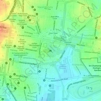
Name: Mysore Palace topographic map, elevation, terrain.
Average elevation: 747 m
Minimum elevation: 728 m
Maximum elevation: 774 m
Make a donation
Gear up for your next adventure:
As an Amazon Associate, this site earns from qualifying purchases at no extra cost to you.
Other topographic maps
Click on a map to view its topography, its elevation and its terrain.
Mysuru
India > Karnataka > Mysuru taluk > Mysuru
Mysore is situated at the foothills of the Chamundi Hills. At an altitude of 770 m (2,530 ft) above mean sea level, the city of Mysore is geographically located at 12° 18′ 26″ north latitude and 76° 38′ 59″ east longitude. It is about 140 km (87.0 mi) southwest of the state's capital, Bangalore, and…
Average elevation: 752 m