
Cochas topographic map
Interactive map
Click on the map to display elevation.
About this map
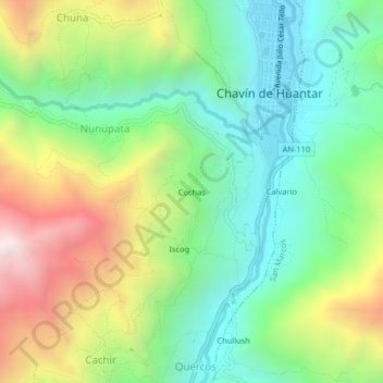
Name: Cochas topographic map, elevation, terrain.
Location: Cochas, Chavín de Huantar, Provincia de Huari, Áncash, Perú (-9.61898 -77.20593 -9.57898 -77.16593)
Average elevation: 3,573 m
Minimum elevation: 3,115 m
Maximum elevation: 4,379 m
Other topographic maps
Click on a map to view its topography, its elevation and its terrain.
Sitio Arqueológico de Chavín
Perú > Áncash > Chavín de Huantar > Cochas
Sitio Arqueológico de Chavín, Cochas, Chavin de Huantar, Chavín de Huantar, Huari, Áncash, Perú
Average elevation: 3,407 m