
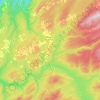
Saint-Jean-de-Cherbourg topographic map
Interactive map
Click on the map to display elevation.
About this map
Name: Saint-Jean-de-Cherbourg topographic map, elevation, terrain.
Average elevation: 333 m
Minimum elevation: 87 m
Maximum elevation: 586 m
Other topographic maps
Click on a map to view its topography, its elevation and its terrain.
Matane
Canada > Québec > La Matanie
Matane, La Matanie, Bas-Saint-Laurent, Québec, Canada
Average elevation: 108 m
Sainte-Félicité
Canada > Québec > La Matanie
Sainte-Félicité, La Matanie, Bas-Saint-Laurent, Québec, G0J 2K0, Canada
Average elevation: 116 m
Lac au Sable
Canada > Québec > La Matanie > Les Méchins
Lac au Sable, Les Méchins, La Matanie, Bas-Saint-Laurent, Québec, Canada
Average elevation: 395 m
Lac Paul
Canada > Québec > La Matanie > Rivière-Bonjour
Lac Paul, Rivière-Bonjour, La Matanie, Bas-Saint-Laurent, Québec, Canada
Average elevation: 578 m
Ruisseau-Gagnon
Canada > Québec > La Matanie > Saint-René-de-Matane
Ruisseau-Gagnon, Saint-René-de-Matane, La Matanie, Bas-Saint-Laurent, Québec, Canada
Average elevation: 153 m
Rivière-Bonjour
Canada > Québec > La Matanie
Rivière-Bonjour, La Matanie, Bas-Saint-Laurent, Québec, Canada, Mont Desjardins
Average elevation: 741 m
Saint-René-de-Matane
Canada > Québec > La Matanie
Saint-René-de-Matane, La Matanie, Bas-Saint-Laurent, Québec, Canada
Average elevation: 155 m
Mont Pointu
Canada > Québec > La Matanie > Rivière-Bonjour
Mont Pointu, Rivière-Bonjour, La Matanie, Bas-Saint-Laurent, Québec, Canada
Average elevation: 649 m
Sainte-Paule
Canada > Québec > La Matanie
Sainte-Paule, La Matanie, Bas-Saint-Laurent, Québec, Canada
Average elevation: 235 m
Mont du Nid-d'Aigle
Canada > Québec > La Matanie > Rivière-Bonjour
Mont du Nid-d'Aigle, Rivière-Bonjour, La Matanie, Bas-Saint-Laurent, Québec, Canada
Average elevation: 498 m
Les Méchins
Canada > Québec > La Matanie
Les Méchins, La Matanie, Bas-Saint-Laurent, Québec, G0J 1T0, Canada
Average elevation: 265 m
Saint-Thomas-de-Cherbourg
Canada > Québec > La Matanie > Les Méchins
Saint-Thomas-de-Cherbourg, Les Méchins, La Matanie, Bas-Saint-Laurent, Québec, Canada
Average elevation: 448 m
Ruisseau-à-Sem
Canada > Québec > La Matanie > Les Méchins > Ruisseau-à-Sem
Ruisseau-à-Sem, Les Méchins, La Matanie, Bas-Saint-Laurent, Québec, Canada
Average elevation: 85 m
Matane
Canada > Québec > La Matanie > Matane
Matane, La Matanie, Bas-Saint-Laurent, Québec, G4W 3B6, Canada
Average elevation: 84 m
Saint-Adelme
Canada > Québec > La Matanie > Saint-Adelme
Saint-Adelme, La Matanie, Bas-Saint-Laurent, Québec, Canada
Average elevation: 237 m
Lac Rouleau
Canada > Québec > La Matanie > Les Méchins
Lac Rouleau, Les Méchins, La Matanie, Bas-Saint-Laurent, Québec, Canada
Average elevation: 385 m
Le Renversé
Canada > Québec > La Matanie > Saint-René-de-Matane > Le Renversé
Le Renversé, Saint-René-de-Matane, La Matanie, Bas-Saint-Laurent, Québec, G0J 3E0, Canada
Average elevation: 270 m
Saint-René-de-Matane
Canada > Québec > La Matanie
Saint-René-de-Matane, La Matanie, Bas-Saint-Laurent, Québec, G0J 3E0, Canada
Average elevation: 234 m
Saint-Léandre
Canada > Québec > La Matanie
Saint-Léandre, La Matanie, Bas-Saint-Laurent, Québec, Canada
Average elevation: 190 m
Baie-des-Sables
Canada > Québec > La Matanie
Baie-des-Sables, La Matanie, Bas-Saint-Laurent, Québec, G0J 1C0, Canada
Average elevation: 70 m
Grosses-Roches
Canada > Québec > La Matanie
Grosses-Roches, La Matanie, Bas-Saint-Laurent, Québec, G0J 1K0, Canada
Average elevation: 164 m
Saint-Ulric
Canada > Québec > La Matanie
Saint-Ulric, La Matanie, Bas-Saint-Laurent, Québec, Canada
Average elevation: 100 m