Geolocate

Jenison topographic map

Click on the map to display elevation.

About this map

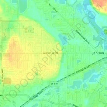
Name: Jenison topographic map, elevation, terrain.

Location: Jenison, Georgetown Charter Township, Ottawa County, Michigan, 49428, United States (42.88527 -85.85262 42.92841 -85.78563)

Average elevation: 192 m

Minimum elevation: 177 m

Maximum elevation: 214 m

Other topographic maps

Click on a map to view its topography, its elevation and its terrain.

Borculo

United States > Michigan > Ottawa County > Olive Township

Average elevation: 197 m

West Olive

United States > Michigan > Ottawa County

Average elevation: 189 m

Wright

United States > Michigan > Ottawa County > Wright Township

Average elevation: 265 m

Aman Park

United States > Michigan > Ottawa County > Tallmadge

Average elevation: 207 m

Grand Valley

United States > Michigan > Ottawa County

Average elevation: 199 m

Port Sheldon

United States > Michigan > Ottawa County

Average elevation: 185 m

Gear up for your next adventure:

🦘Outback Survival Gear - Essential gear for Australian outback
🚴Cycling Backpacks - Backpacks for cyclists
🧥Thermal Emergency Blankets - Compact Mylar blankets to prevent hypothermia if stranded overnight
Outdoor Coffee Makers - Enjoy quality coffee at the summit of your favorite peak
🌧️Rain Jackets - Waterproof jackets for hiking

As an Amazon Associate, this site earns from qualifying purchases at no extra cost to you.