
Make a donation
Gear up for your next adventure:
As an Amazon Associate, this site earns from qualifying purchases at no extra cost to you.
Yucca Valley topographic map
Click on the map to display elevation.
Make a donation
Gear up for your next adventure:
As an Amazon Associate, this site earns from qualifying purchases at no extra cost to you.
Yucca Valley
Yucca Valley lies in the middle of the Morongo Basin at a base elevation of 3,300 feet. Joshua Tree National Park is adjacent to its southern border.
Make a donation
Gear up for your next adventure:
As an Amazon Associate, this site earns from qualifying purchases at no extra cost to you.
About this map
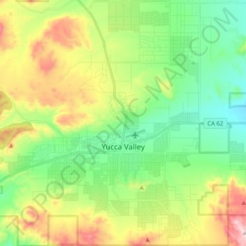
Name: Yucca Valley topographic map, elevation, terrain.
Average elevation: 1,106 m
Minimum elevation: 896 m
Maximum elevation: 1,499 m
Make a donation
Gear up for your next adventure:
As an Amazon Associate, this site earns from qualifying purchases at no extra cost to you.
Other topographic maps
Click on a map to view its topography, its elevation and its terrain.
Big Bear Lake
United States > California > San Bernardino County > Big Bear Lake
At a surface elevation of 6,743 ft (2,055 m) above sea level, it has an east-west length of approximately seven miles (11 km) and is approximately 2.5 miles (4.0 km) at its widest measurement, though the lake's width mostly averages a little more than 1⁄2 mi (0.8 km). These approximations are based on the…
Average elevation: 2,209 m
Fort Irwin
United States > California > San Bernardino County
Fort Irwin National Training Center (Fort Irwin NTC) is a major training area for the United States military in the Mojave Desert in northern San Bernardino County, California. Fort Irwin is at an average elevation of 2,454 feet (748 m). It is located 37 miles (60 km) northeast of Barstow, in the Calico…
Average elevation: 774 m
Sugarloaf
United States > California > San Bernardino County > Big Bear City
Average elevation: 2,154 m
Make a donation
Gear up for your next adventure:
As an Amazon Associate, this site earns from qualifying purchases at no extra cost to you.
Fredalba
United States > California > San Bernardino County > Running Springs
Average elevation: 1,547 m
Make a donation
Gear up for your next adventure:
As an Amazon Associate, this site earns from qualifying purchases at no extra cost to you.
Desert Knolls Manor
United States > California > San Bernardino County > Apple Valley
Average elevation: 928 m
Santa Ana River Trail & Parkway
United States > California > San Bernardino County > San Bernardino
Average elevation: 310 m
Make a donation
Gear up for your next adventure:
As an Amazon Associate, this site earns from qualifying purchases at no extra cost to you.
Make a donation
Gear up for your next adventure:
As an Amazon Associate, this site earns from qualifying purchases at no extra cost to you.
Big Bear City
United States > California > San Bernardino County
It is estimated that the Serrano natives first settled in Big Bear between 1,500 and 2,000 years ago. The Serranos had both winter and summer settlements throughout the area. While their winter village was located in Lucerne Valley, they relocated to villages in the San Bernardino mountains during summer, as…
Average elevation: 2,167 m
Eagle Ranch
United States > California > San Bernardino County > Victorville
Average elevation: 1,006 m
Make a donation
Gear up for your next adventure:
As an Amazon Associate, this site earns from qualifying purchases at no extra cost to you.
Arrowhead Highlands
United States > California > San Bernardino County > Crestline
Average elevation: 1,405 m
Make a donation
Gear up for your next adventure:
As an Amazon Associate, this site earns from qualifying purchases at no extra cost to you.
Make a donation
Gear up for your next adventure:
As an Amazon Associate, this site earns from qualifying purchases at no extra cost to you.
Grand Terrace
United States > California > San Bernardino County > Grand Terrace > Grand Terrace
This 3.6-square-mile (9.3 km2) community has an average elevation of 1,065 feet (325 m). Its motto, inscribed on the city flag, is "The Blue Mountain City" (its official slogan is "A city set upon a mountain cannot be hidden"), and refers to the Blue Lupine flower that used to grow on Blue Mountain in the…
Average elevation: 345 m
North Shore
United States > California > San Bernardino County > Lake Arrowhead
Average elevation: 1,585 m
Make a donation
Gear up for your next adventure:
As an Amazon Associate, this site earns from qualifying purchases at no extra cost to you.
Serrano Village
United States > California > San Bernardino County > San Bernardino
Average elevation: 489 m
Make a donation
Gear up for your next adventure:
As an Amazon Associate, this site earns from qualifying purchases at no extra cost to you.
Grapeland
United States > California > San Bernardino County > Rancho Cucamonga
Average elevation: 423 m
Sand to Snow National Monument
United States > California > San Bernardino County
Sand dunes are home to the endangered fringe-toed lizard at the lower elevation confluence of the Whitewater and San Gorgonio Rivers, while Desert bighorn sheep are found at higher elevations.
Average elevation: 1,423 m
Make a donation
Gear up for your next adventure:
As an Amazon Associate, this site earns from qualifying purchases at no extra cost to you.
Make a donation
Gear up for your next adventure:
As an Amazon Associate, this site earns from qualifying purchases at no extra cost to you.
Badger Hill
United States > California > San Bernardino County > San Bernardino
Average elevation: 525 m
Oak Glen
United States > California > San Bernardino County
Oak Glen is a census-designated place situated between the San Bernardino Mountains and the Little San Bernardino Mountains in San Bernardino County, California, United States. Oak Glen is located 15 miles east of San Bernardino, at an elevation of 4,734 feet (1,443 m). The population was 638 at the 2010…
Average elevation: 1,502 m
Make a donation
Gear up for your next adventure:
As an Amazon Associate, this site earns from qualifying purchases at no extra cost to you.
North Ontario
United States > California > San Bernardino County > Upland > North Ontario
Average elevation: 373 m
Make a donation
Gear up for your next adventure:
As an Amazon Associate, this site earns from qualifying purchases at no extra cost to you.
Make a donation
Gear up for your next adventure:
As an Amazon Associate, this site earns from qualifying purchases at no extra cost to you.
Etiwanda
United States > California > San Bernardino County > Rancho Cucamonga
Average elevation: 415 m
Rochester
United States > California > San Bernardino County > Rancho Cucamonga > Rochester
Average elevation: 343 m
Make a donation
Gear up for your next adventure:
As an Amazon Associate, this site earns from qualifying purchases at no extra cost to you.