
Pachuquilla topographic map
Interactive map
Click on the map to display elevation.
About this map
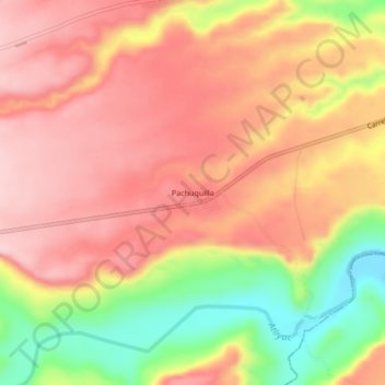
Name: Pachuquilla topographic map, elevation, terrain.
Location: Pachuquilla, Puente Nacional, Veracruz, México (19.21861 -96.63306 19.25861 -96.59306)
Average elevation: 312 m
Minimum elevation: 174 m
Maximum elevation: 396 m
Other topographic maps
Click on a map to view its topography, its elevation and its terrain.
Río Huitzilapan
México > Veracruz > Puente Nacional
Río Huitzilapan, Puente Nacional, Veracruz, México
Average elevation: 185 m
Chichicaxtle
México > Veracruz > Puente Nacional
Chichicaxtle, Puente Nacional, Veracruz, México
Average elevation: 101 m
Puente Nacional
México > Veracruz > Puente Nacional
Puente Nacional, Veracruz, 91653, México
Average elevation: 236 m