Geolocate

Menlo topographic map

Click on the map to display elevation.

About this map

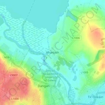
Name: Menlo topographic map, elevation, terrain.

Location: Menlo, County Galway, Connacht, H91 CF90, Ireland (53.28235 -9.09356 53.32235 -9.05356)

Average elevation: 22 m

Minimum elevation: -2 m

Maximum elevation: 77 m

Gear up for your next adventure:

🔪Outdoor Multi-tools - Versatile tools for gear repair and survival tasks in the wilderness
🧥Down Jackets - Insulated jackets for cold weather
💧Personal Water Filters - Drink safely from streams and lakes identified on your map
🧦Hiking Socks - Comfortable socks for long hikes
🦶Orthotic Hiking Insoles - Extra arch support for long-distance topographic treks

As an Amazon Associate, this site earns from qualifying purchases at no extra cost to you.