
Bear Mountain topographic map
Interactive map
Click on the map to display elevation.
About this map
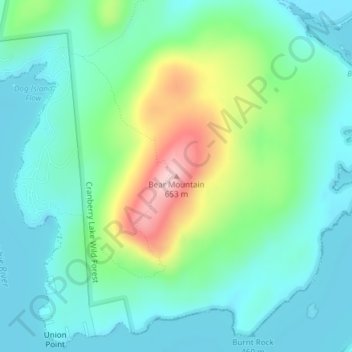
Name: Bear Mountain topographic map, elevation, terrain.
Average elevation: 504 m
Minimum elevation: 448 m
Maximum elevation: 659 m
Other topographic maps
Click on a map to view its topography, its elevation and its terrain.
Town of Massena
United States > New York > Saint Lawrence County
Town of Massena, Saint Lawrence County, New York, United States
Average elevation: 70 m
Village of Potsdam
United States > New York > Saint Lawrence County > Town of Potsdam
Village of Potsdam, Town of Potsdam, Saint Lawrence County, New York, 13699, United States
Average elevation: 133 m
Village of Waddington
United States > New York > Saint Lawrence County
Village of Waddington, Town of Waddington, Saint Lawrence County, New York, 13694, United States
Average elevation: 80 m
Wildwood
United States > New York > Saint Lawrence County > Town of Colton
Wildwood, Town of Colton, Saint Lawrence County, New York, 13625, United States
Average elevation: 306 m
Hermon
United States > New York > Saint Lawrence County > Hermon
Hermon, Saint Lawrence County, New York, 13652, United States
Average elevation: 159 m