
Make a donation
Gear up for your next adventure:
As an Amazon Associate, this site earns from qualifying purchases at no extra cost to you.
Roborst topographic map
Click on the map to display elevation.
Make a donation
Gear up for your next adventure:
As an Amazon Associate, this site earns from qualifying purchases at no extra cost to you.
Roborst
Roborst ligt in Zandlemig Vlaanderen op een hoogte van 20-85 meter. Ten oosten van de dorpskern loopt de Zwalm in noordwestelijke richting.
Make a donation
Gear up for your next adventure:
As an Amazon Associate, this site earns from qualifying purchases at no extra cost to you.
About this map
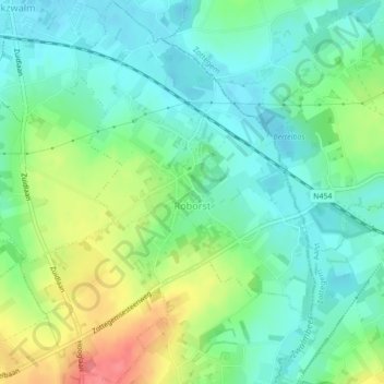
Name: Roborst topographic map, elevation, terrain.
Location: Roborst, Zwalm, Oudenaarde, Oost-Vlaanderen, Vlaanderen, België (50.85091 3.73417 50.87820 3.76736)
Average elevation: 40 m
Minimum elevation: 16 m
Maximum elevation: 90 m
Make a donation
Gear up for your next adventure:
As an Amazon Associate, this site earns from qualifying purchases at no extra cost to you.
Other topographic maps
Click on a map to view its topography, its elevation and its terrain.
Make a donation
Gear up for your next adventure:
As an Amazon Associate, this site earns from qualifying purchases at no extra cost to you.