
Sewastopol topographic map
Interactive map
Click on the map to display elevation.
About this map
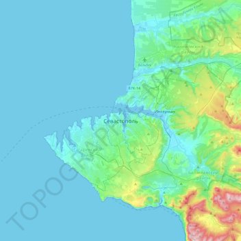
Name: Sewastopol topographic map, elevation, terrain.
Location: Sewastopol, 299911, Ukraine (44.44544 33.36208 44.76544 33.68208)
Average elevation: 73 m
Minimum elevation: -2 m
Maximum elevation: 617 m
Nicht zu übersehen ist das Denkmal für Soldat und Seemann unweit der Adler-Säule. Sein Bau zog sich jahrzehntelang (1972–1989) hin, bis die Finanzierung durch die ukrainische Regierung übernommen wurde. Die Höhe beträgt 41 Meter.