
Thank you for supporting this site ❤️
Make a donation
Make a donation
Gear up for your next adventure:
As an Amazon Associate, this site earns from qualifying purchases at no extra cost to you.
Tudes topographic map
Click on the map to display elevation.
Thank you for supporting this site ❤️
Make a donation
Make a donation
Gear up for your next adventure:
As an Amazon Associate, this site earns from qualifying purchases at no extra cost to you.
About this map
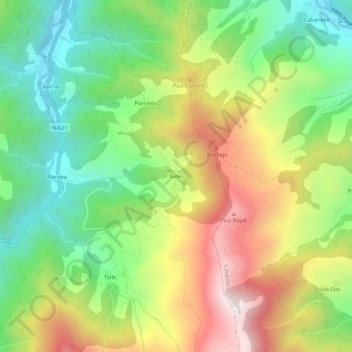
Name: Tudes topographic map, elevation, terrain.
Location: Tudes, Vega de Liébana, Liébana, Cantabria, 39575, Spain (43.10138 -4.63078 43.14138 -4.59078)
Average elevation: 685 m
Minimum elevation: 319 m
Maximum elevation: 1,192 m
Thank you for supporting this site ❤️
Make a donation
Make a donation
Gear up for your next adventure:
As an Amazon Associate, this site earns from qualifying purchases at no extra cost to you.