
Hanmer Springs topographic map
Click on the map to display elevation.
Hanmer Springs
The Jacks Pass – Clarence River – Jollies Pass Loop is a 25 kilometres (16 mi) loop which is not technically challenging; however, it takes between two and four hours to complete. It can be ridden in either direction: West over Jacks Pass (869 m) or East over Jollies Pass (850 m). As the entire ride is at high elevation (700 m above sea level) it is subject to extreme and sudden changes in the weather which have caught riders out who were not prepared.
About this map
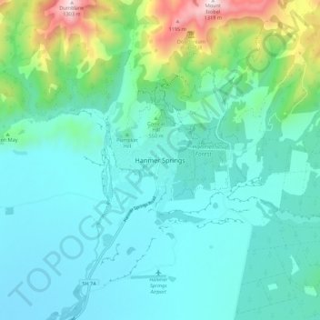
Name: Hanmer Springs topographic map, elevation, terrain.
Average elevation: 490 m
Minimum elevation: 295 m
Maximum elevation: 1,318 m
Other topographic maps
Click on a map to view its topography, its elevation and its terrain.