Geolocate

Gunn topographic map

Interactive map

Click on the map to display elevation.

About this map

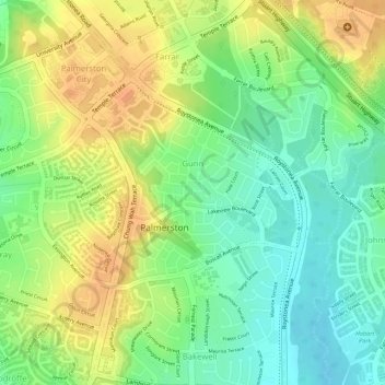
Name: Gunn topographic map, elevation, terrain.

Location: Gunn, City of Palmerston, Northern Territory, Australia (-12.49417 130.98644 -12.48096 131.00068)

Average elevation: 32 m

Minimum elevation: 11 m

Maximum elevation: 52 m

Other topographic maps

Click on a map to view its topography, its elevation and its terrain.

Woodroffe

Australia > City of Palmerston

Woodroffe, City of Palmerston, Northern Territory, 0830, Australia

Average elevation: 24 m

Palmerston

Australia > City of Palmerston

Palmerston, City of Palmerston, Northern Territory, 0830, Australia

Average elevation: 25 m

Driver

Australia > City of Palmerston > Palmerston

Driver, Palmerston, City of Palmerston, Northern Territory, 0830, Australia

Average elevation: 25 m

Bakewell

Australia > City of Palmerston > Palmerston

Bakewell, Palmerston, City of Palmerston, Northern Territory, 0830, Australia

Average elevation: 26 m

Durack

Australia > City of Palmerston

Durack, City of Palmerston, Northern Territory, Australia

Average elevation: 26 m

Moulden

Australia > City of Palmerston

Moulden, City of Palmerston, Northern Territory, Australia

Average elevation: 19 m

Gray

Australia > City of Palmerston > Palmerston

Gray, Palmerston, City of Palmerston, Northern Territory, 0830, Australia

Average elevation: 31 m

Zuccoli

Australia > City of Palmerston

Zuccoli, City of Palmerston, Northern Territory, Australia

Average elevation: 18 m

Palmerston City

Australia > City of Palmerston

Palmerston City, City of Palmerston, Northern Territory, Australia

Average elevation: 33 m