
Make a donation
Gear up for your next adventure:
As an Amazon Associate, this site earns from qualifying purchases at no extra cost to you.
Le Maravant topographic map
Click on the map to display elevation.
Make a donation
Gear up for your next adventure:
As an Amazon Associate, this site earns from qualifying purchases at no extra cost to you.
About this map
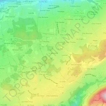
Name: Le Maravant topographic map, elevation, terrain.
Average elevation: 862 m
Minimum elevation: 703 m
Maximum elevation: 1,082 m
Make a donation
Gear up for your next adventure:
As an Amazon Associate, this site earns from qualifying purchases at no extra cost to you.
Other topographic maps
Click on a map to view its topography, its elevation and its terrain.
Lac de la Beunaz
France > Auvergne-Rhône-Alpes > Haute-Savoie > Saint-Paul-en-Chablais > La Gottetaz
Il arrive au lac de la Beunaz le 15 avril 1951 et découvre que le lac présente une eau relativement tempéré 16 °C malgré une altitude de 1 000 m. Il décide alors de convertir le lac de la Beunaz en espace de baignade. Il obtient pour cela une concession de la mairie de Saint-Paul-en-Chablais et avec…
Average elevation: 954 m
Marais du Maravant
France > Auvergne-Rhône-Alpes > Haute-Savoie > Saint-Paul-en-Chablais > Le Maravant
Average elevation: 856 m
74500
France > Auvergne-Rhône-Alpes > Haute-Savoie > Saint-Paul-en-Chablais > Serres
Average elevation: 935 m