Geolocate

Camarin topographic map

Click on the map to display elevation.

About this map
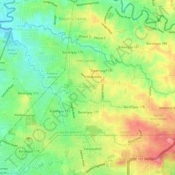
Name: Camarin topographic map, elevation, terrain.

Location: Camarin, District 1, Caloocan, Northern Manila District, Metro Manila, Philippines (14.73806 121.02676 14.77327 121.07793)

Average elevation: 68 m

Minimum elevation: 30 m

Maximum elevation: 113 m

Other topographic maps

Click on a map to view its topography, its elevation and its terrain.

Caybiga

Philippines > Caloocan

Average elevation: 38 m

Caybiga

Philippines > Caloocan

Average elevation: 38 m

Caybiga

Philippines > Caloocan

Average elevation: 38 m

Gear up for your next adventure:

🥤Outdoor Water Bottles - Reusable bottles for outdoor activities
⌛Survival Blankets - Emergency thermal blankets
🔋Solar Power Banks - Charge your phone and GPS using the sun while deep in the bush
🧯Animal Deterrent Spray - Safety spray for wildlife
🧣Merino Neck Gaiters - Versatile headwear for warmth, sun protection, or dust filtering

As an Amazon Associate, this site earns from qualifying purchases at no extra cost to you.