
Rif Dimashq Governorate topographic map
Interactive map
Click on the map to display elevation.
About this map
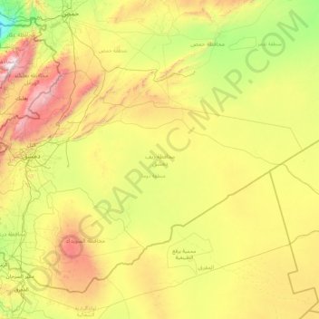
Name: Rif Dimashq Governorate topographic map, elevation, terrain.
Location: Rif Dimashq Governorate, Syria (32.69255 35.81246 34.24892 39.13386)
Average elevation: 775 m
Minimum elevation: 4 m
Maximum elevation: 3,044 m
Other topographic maps
Click on a map to view its topography, its elevation and its terrain.
Has
Hass (Arabic: حَاسٌّ, romanized: Ḥāss) is a town in northwestern Syria, administratively part of the Ma'arrat al-Numan District of the Idlib Governorate. The town has an altitude of 630 meters above sea level. According to the Syria Central Bureau of Statistics, Hass had a population of 9,595 in the…
Average elevation: 591 m