
Portneuf-sur-Mer topographic map
Interactive map
Click on the map to display elevation.
About this map
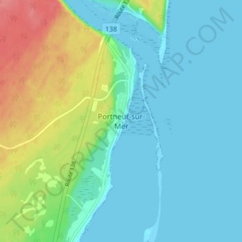
Name: Portneuf-sur-Mer topographic map, elevation, terrain.
Average elevation: 18 m
Minimum elevation: -2 m
Maximum elevation: 70 m
Other topographic maps
Click on a map to view its topography, its elevation and its terrain.
La Grande Savane
Canada > Québec > La Haute-Côte-Nord > Portneuf-sur-Mer
La Grande Savane, Portneuf-sur-Mer, La Haute-Côte-Nord, Côte-Nord, Québec, G0T 1P0, Canada
Average elevation: 33 m