
Chattarpur topographic map
Interactive map
Click on the map to display elevation.
About this map
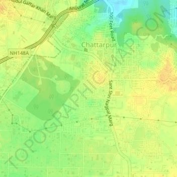
Name: Chattarpur topographic map, elevation, terrain.
Location: Chattarpur, Saket Tehsil, South Delhi, Delhi, 110074, India (28.48714 77.17125 28.50714 77.19125)
Average elevation: 261 m
Minimum elevation: 244 m
Maximum elevation: 269 m
Other topographic maps
Click on a map to view its topography, its elevation and its terrain.
Sainik Farm
India > Delhi > Saket Tehsil
Sainik Farm, Saket Tehsil, South Delhi, Delhi, India
Average elevation: 239 m
Qila Rai Pithora
India > Delhi > Saket Tehsil
Qila Rai Pithora, Lado Sarai, Saket Tehsil, South Delhi, Delhi, 110030, India
Average elevation: 242 m