
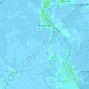
Abbenbroek topographic map
Interactive map
Click on the map to display elevation.
About this map
Name: Abbenbroek topographic map, elevation, terrain.
Location: Abbenbroek, Nissewaard, Zuid-Holland, Nederland (51.82494 4.19273 51.85496 4.26258)
Average elevation: 0 m
Minimum elevation: -4 m
Maximum elevation: 6 m
Other topographic maps
Click on a map to view its topography, its elevation and its terrain.
Bernisse
Nederland > Zuid-Holland > Nissewaard
Bernisse, Nissewaard, Zuid-Holland, Nederland, 3214LV, Nederland
Average elevation: 0 m
Nissewaard
Nederland > Zuid-Holland > Nissewaard
Nissewaard, Zuid-Holland, Nederland
Average elevation: 1 m
Geervliet
Nederland > Zuid-Holland > Nissewaard > Geervliet
Geervliet, Nissewaard, Zuid-Holland, Nederland
Average elevation: 0 m
Bernisse
Nederland > Zuid-Holland > Nissewaard
Bernisse, Nissewaard, Zuid-Holland, Nederland, 3218 AV, Nederland
Average elevation: 0 m