Geolocate

Bellevue topographic map

Click on the map to display elevation.

About this map

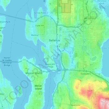
Name: Bellevue topographic map, elevation, terrain.

Location: Bellevue, King County, Washington, United States (47.53501 -122.22281 47.66079 -122.08722)

Average elevation: 66 m

Minimum elevation: -3 m

Maximum elevation: 455 m

Other topographic maps

Click on a map to view its topography, its elevation and its terrain.

Somerset

United States > Washington > King County > Bellevue

Average elevation: 131 m

Riverton

United States > Washington > King County > Tukwila

Average elevation: 77 m

Gear up for your next adventure:

🔋Solar Power Banks - Charge your phone and GPS using the sun while deep in the bush
📚Map Reading & Navigation Guides - Master the art of interpreting topographic contours and symbols
📡Portable Emergency Radios - Stay informed about weather warnings and bushfire alerts
🪢Paracord - Multi-purpose survival cord
🧭Compass - Navigation compasses for outdoor exploration

As an Amazon Associate, this site earns from qualifying purchases at no extra cost to you.