
Burnley topographic map
Interactive map
Click on the map to display elevation.
About this map
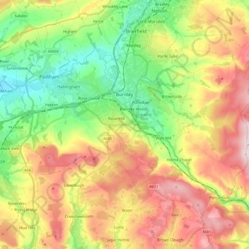
Name: Burnley topographic map, elevation, terrain.
Location: Burnley, Lancashire, England, United Kingdom (53.72300 -2.34231 53.82526 -2.11228)
Average elevation: 247 m
Minimum elevation: 63 m
Maximum elevation: 479 m
The town lies in a natural three-forked valley at the confluence of the River Brun and the River Calder, surrounded by open fields, with wild moorland at higher altitudes. To the west of Burnley lie the towns of Padiham, Accrington and Blackburn, with Nelson and Colne to the north. The centre of the town stands at approximately 387 feet (118 m) above sea level and 30 miles (48 km) east of the Irish Sea coast.
Other topographic maps
Click on a map to view its topography, its elevation and its terrain.
Catterall
United Kingdom > England > Lancashire > Borough of Wyre
Catterall, Borough of Wyre, Lancashire, England, PR3 0LR, United Kingdom
Average elevation: 22 m
Wilpshire
United Kingdom > England > Lancashire > Ribble Valley
Wilpshire, Ribble Valley, Lancashire, England, United Kingdom
Average elevation: 149 m
Churchtown
United Kingdom > England > Lancashire > Borough of Wyre
Churchtown, Borough of Wyre, Lancashire, England, PR3 0LQ, United Kingdom
Average elevation: 15 m
Kirkham
United Kingdom > England > Lancashire > Borough of Fylde > Wesham
Kirkham, Wesham, Borough of Fylde, Lancashire, England, United Kingdom
Average elevation: 22 m
Haskayne
United Kingdom > England > Lancashire > West Lancashire
Haskayne, West Lancashire, Lancashire, England, L39 7JE, United Kingdom
Average elevation: 13 m
Skelmersdale
United Kingdom > England > Lancashire > West Lancashire
Skelmersdale, West Lancashire, Lancashire, England, WN8 6ES, United Kingdom
Average elevation: 68 m
Euxton
United Kingdom > England > Lancashire > Chorley
Euxton, Chorley, Lancashire, England, United Kingdom
Average elevation: 50 m
Water
United Kingdom > England > Lancashire > Borough of Rossendale > Water
Water, Borough of Rossendale, Lancashire, England, BB4 9PX, United Kingdom
Average elevation: 325 m
Preston
United Kingdom > England > Lancashire > Preston
Preston, Lancashire, North West England, England, PR2 0ZH, United Kingdom
Average elevation: 80 m
Manchester
United Kingdom > England > Lancashire > Manchester
Manchester, Lancashire, North West England, England, M60 2TU, United Kingdom
Average elevation: 118 m
Pendle Hill
United Kingdom > England > Lancashire > Borough of Pendle
Pendle Hill, Borough of Pendle, Lancashire, England, BB9 6LQ, United Kingdom
Average elevation: 385 m