Geolocate

Islands topographic map

Click on the map to display elevation.

About this map

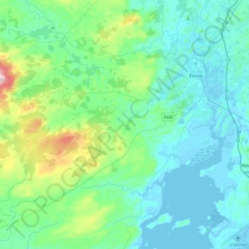
Name: Islands topographic map, elevation, terrain.

Location: Islands, County Clare, Munster, Ireland (52.71958 -9.27565 52.88054 -8.90874)

Average elevation: 64 m

Minimum elevation: -2 m

Maximum elevation: 386 m

Other topographic maps

Click on a map to view its topography, its elevation and its terrain.

Cliffs of Moher

Ireland > County Clare

Average elevation: 55 m

Connolly

Ireland > County Clare

Average elevation: 96 m

Ruan

Ireland > County Clare

Average elevation: 22 m

Gear up for your next adventure:

🪢Paracord - Multi-purpose survival cord
💡Collapsible Camping Lanterns - Illuminate your base camp or tent for map studying at night
🩹First Aid Kits - Emergency kits for hiking
🔦LED Torches - LED torches for outdoor use
📖Australian Bush Survival Books - Local knowledge on finding water and surviving the outback

As an Amazon Associate, this site earns from qualifying purchases at no extra cost to you.