
Thank you for supporting this site ❤️
Make a donation
Make a donation
Gear up for your next adventure:
As an Amazon Associate, this site earns from qualifying purchases at no extra cost to you.
Albion topographic map
Click on the map to display elevation.
Thank you for supporting this site ❤️
Make a donation
Make a donation
Gear up for your next adventure:
As an Amazon Associate, this site earns from qualifying purchases at no extra cost to you.
About this map
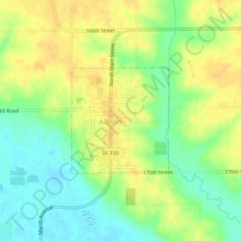
Name: Albion topographic map, elevation, terrain.
Location: Albion, Iowa Township, Marshall County, Iowa, United States (42.10661 -92.99592 42.11849 -92.98128)
Average elevation: 284 m
Minimum elevation: 269 m
Maximum elevation: 297 m
Thank you for supporting this site ❤️
Make a donation
Make a donation
Gear up for your next adventure:
As an Amazon Associate, this site earns from qualifying purchases at no extra cost to you.
Other topographic maps
Click on a map to view its topography, its elevation and its terrain.
Saint Anthony
United States > Iowa > Marshall County > St. Anthony > Saint Anthony
Average elevation: 317 m