Geolocate

Arona topographic map

Click on the map to display elevation.

About this map
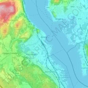
Name: Arona topographic map, elevation, terrain.

Location: Arona, Novara, Piedmont, Italy (45.72521 8.49664 45.78496 8.57964)

Average elevation: 249 m

Minimum elevation: 190 m

Maximum elevation: 517 m

Other topographic maps

Click on a map to view its topography, its elevation and its terrain.

Case Sparse di Cameriano

Italy > Piedmont > Novara > Casalino > Cameriano

Average elevation: 141 m

Agrate

Italy > Piedmont > Novara

Average elevation: 324 m

Gaggiolo

Italy > Piedmont > Novara

Average elevation: 211 m

Pisogno

Italy > Piedmont > Novara > Miasino

Average elevation: 527 m

Gear up for your next adventure:

🔦Headlamps - Hands-free lighting for hiking
🧭Global Orienteering Compass - High-precision liquid-filled compasses for accurate map reading and navigation
⌚GPS Watches - GPS watches for outdoor sports
🥶Thermal Beanies - Warm hats for cold hikes
🔭Compact Hiking Binoculars - Lightweight optics for scouting routes or birdwatching

As an Amazon Associate, this site earns from qualifying purchases at no extra cost to you.