
Make a donation
Gear up for your next adventure:
As an Amazon Associate, this site earns from qualifying purchases at no extra cost to you.
Swainsthorpe topographic map
Click on the map to display elevation.
Make a donation
Gear up for your next adventure:
As an Amazon Associate, this site earns from qualifying purchases at no extra cost to you.
About this map
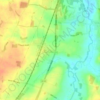
Name: Swainsthorpe topographic map, elevation, terrain.
Location: Swainsthorpe, South Norfolk, Norfolk, England, United Kingdom (52.55093 1.25576 52.57176 1.29312)
Average elevation: 26 m
Minimum elevation: 5 m
Maximum elevation: 47 m
Make a donation
Gear up for your next adventure:
As an Amazon Associate, this site earns from qualifying purchases at no extra cost to you.
Other topographic maps
Click on a map to view its topography, its elevation and its terrain.
Poringland Wood
United Kingdom > England > Norfolk > South Norfolk > Framingham Earl
Average elevation: 50 m
Make a donation
Gear up for your next adventure:
As an Amazon Associate, this site earns from qualifying purchases at no extra cost to you.
Fundenhall
United Kingdom > England > Norfolk > South Norfolk > Ashwellthorpe and Fundenhall
Average elevation: 50 m
Make a donation
Gear up for your next adventure:
As an Amazon Associate, this site earns from qualifying purchases at no extra cost to you.
Make a donation
Gear up for your next adventure:
As an Amazon Associate, this site earns from qualifying purchases at no extra cost to you.
Highoak
United Kingdom > England > Norfolk > South Norfolk > Morley St Botolph
Average elevation: 47 m
Make a donation
Gear up for your next adventure:
As an Amazon Associate, this site earns from qualifying purchases at no extra cost to you.
Beckhithe
United Kingdom > England > Norfolk > South Norfolk > Little Melton > Beckhithe
Average elevation: 37 m
Make a donation
Gear up for your next adventure:
As an Amazon Associate, this site earns from qualifying purchases at no extra cost to you.
Make a donation
Gear up for your next adventure:
As an Amazon Associate, this site earns from qualifying purchases at no extra cost to you.
Make a donation
Gear up for your next adventure:
As an Amazon Associate, this site earns from qualifying purchases at no extra cost to you.