
Mariposa Grove topographic map
Interactive map
Click on the map to display elevation.
About this map
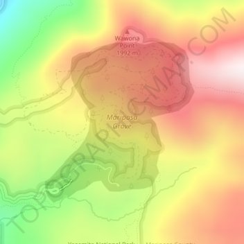
Name: Mariposa Grove topographic map, elevation, terrain.
Location: Mariposa Grove, Mariposa County, California, United States (37.50002 -119.61262 37.51780 -119.59174)
Average elevation: 1,865 m
Minimum elevation: 1,453 m
Maximum elevation: 2,187 m
Other topographic maps
Click on a map to view its topography, its elevation and its terrain.
Yosemite Valley
United States > California > Mariposa County > Yosemite Village
Yosemite Valley, Yosemite Village, Mariposa County, California, United States
Average elevation: 2,016 m
Middle Brother
United States > California > Mariposa County
Middle Brother, Mariposa County, California, 95389, United States
Average elevation: 1,776 m