
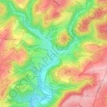
Irrhausen topographic map
Interactive map
Click on the map to display elevation.
About this map
Name: Irrhausen topographic map, elevation, terrain.
Average elevation: 443 m
Minimum elevation: 340 m
Maximum elevation: 536 m
Other topographic maps
Click on a map to view its topography, its elevation and its terrain.
Bettingen
Deutschland > Rheinland-Pfalz > Eifelkreis Bitburg-Prüm
Bettingen, Bitburger Land, Eifelkreis Bitburg-Prüm, Rheinland-Pfalz, 54646, Deutschland
Average elevation: 302 m
Winterscheid
Deutschland > Rheinland-Pfalz > Eifelkreis Bitburg-Prüm
Winterscheid, Prüm, Eifelkreis Bitburg-Prüm, Rheinland-Pfalz, Deutschland
Average elevation: 487 m
Seimerich
Deutschland > Rheinland-Pfalz > Eifelkreis Bitburg-Prüm
Seimerich, Körperich, Südeifel, Eifelkreis Bitburg-Prüm, Rheinland-Pfalz, 54675, Deutschland
Average elevation: 289 m
Heckhalenfeld
Deutschland > Rheinland-Pfalz > Eifelkreis Bitburg-Prüm > Winterspelt
Heckhalenfeld, Winterspelt, Prüm, Eifelkreis Bitburg-Prüm, Rheinland-Pfalz, 54616, Deutschland
Average elevation: 480 m
Mützenich
Deutschland > Rheinland-Pfalz > Eifelkreis Bitburg-Prüm
Mützenich, Prüm, Eifelkreis Bitburg-Prüm, Rheinland-Pfalz, Deutschland
Average elevation: 507 m
Schweiler
Deutschland > Rheinland-Pfalz > Eifelkreis Bitburg-Prüm > Mützenich
Schweiler, Mützenich, Prüm, Eifelkreis Bitburg-Prüm, Rheinland-Pfalz, Deutschland
Average elevation: 498 m
Gemünd
Deutschland > Rheinland-Pfalz > Eifelkreis Bitburg-Prüm > Gemünd
Gemünd, Südeifel, Eifelkreis Bitburg-Prüm, Rheinland-Pfalz, Deutschland
Average elevation: 341 m
Prüm
Deutschland > Rheinland-Pfalz > Eifelkreis Bitburg-Prüm
Prüm, Eifelkreis Bitburg-Prüm, Rheinland-Pfalz, 54595, Deutschland
Average elevation: 494 m