
Make a donation
Gear up for your next adventure:
As an Amazon Associate, this site earns from qualifying purchases at no extra cost to you.
Schollbrunn topographic map
Click on the map to display elevation.
Make a donation
Gear up for your next adventure:
As an Amazon Associate, this site earns from qualifying purchases at no extra cost to you.
Schollbrunn
Die Gemeinde liegt in der Region Würzburg. Der topographisch höchste Punkt der Gemeindegemarkung befindet sich mit 465 m ü. NHN an der St 2316 nordwestlich von Schollbrunn, der niedrigste liegt am Kropfbach auf 174 m ü. NHN.
Make a donation
Gear up for your next adventure:
As an Amazon Associate, this site earns from qualifying purchases at no extra cost to you.
About this map
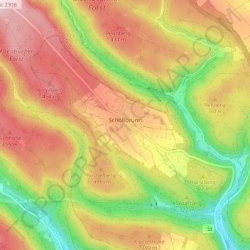
Name: Schollbrunn topographic map, elevation, terrain.
Average elevation: 350 m
Minimum elevation: 163 m
Maximum elevation: 518 m
Make a donation
Gear up for your next adventure:
As an Amazon Associate, this site earns from qualifying purchases at no extra cost to you.
Other topographic maps
Click on a map to view its topography, its elevation and its terrain.
Gut Ebenroth
Deutschland > Bayern > Landkreis Main-Spessart > Arnstein > Reuchelheim
Average elevation: 297 m
Make a donation
Gear up for your next adventure:
As an Amazon Associate, this site earns from qualifying purchases at no extra cost to you.
Neustadt a. Main
Deutschland > Bayern > Landkreis Main-Spessart > Neustadt a.Main
Average elevation: 299 m
Marktheidenfeld
Deutschland > Bayern > Landkreis Main-Spessart > Marktheidenfeld > Marktheidenfeld
Average elevation: 236 m
Make a donation
Gear up for your next adventure:
As an Amazon Associate, this site earns from qualifying purchases at no extra cost to you.
Brückenfundamentloch Reichsautobahn Strecke 46, Fulda-Würzburg
Deutschland > Bayern > Landkreis Main-Spessart > Gemünden am Main > Seifriedsburg
Average elevation: 307 m
Eichenfürst
Deutschland > Bayern > Landkreis Main-Spessart > Marktheidenfeld > Altfeld
Average elevation: 253 m
Make a donation
Gear up for your next adventure:
As an Amazon Associate, this site earns from qualifying purchases at no extra cost to you.
Hasberg
Deutschland > Bayern > Landkreis Main-Spessart > Ruppertshüttener Forst
Average elevation: 417 m
Make a donation
Gear up for your next adventure:
As an Amazon Associate, this site earns from qualifying purchases at no extra cost to you.
Make a donation
Gear up for your next adventure:
As an Amazon Associate, this site earns from qualifying purchases at no extra cost to you.
Bayerische Schanz (507,9)
Deutschland > Bayern > Landkreis Main-Spessart > Lohr am Main
Average elevation: 491 m
Make a donation
Gear up for your next adventure:
As an Amazon Associate, this site earns from qualifying purchases at no extra cost to you.
Rengersbrunn
Deutschland > Bayern > Landkreis Main-Spessart > Fellen > Rengersbrunn
Average elevation: 437 m
Make a donation
Gear up for your next adventure:
As an Amazon Associate, this site earns from qualifying purchases at no extra cost to you.
Arnstein
Deutschland > Bayern > Landkreis Main-Spessart > Arnstein > Arnstein
Average elevation: 279 m
Adelsberg
Deutschland > Bayern > Landkreis Main-Spessart > Gemünden am Main > Adelsberg
Average elevation: 246 m
Seifriedsburg
Deutschland > Bayern > Landkreis Main-Spessart > Gemünden am Main
Average elevation: 289 m
Make a donation
Gear up for your next adventure:
As an Amazon Associate, this site earns from qualifying purchases at no extra cost to you.
Langenprozelten
Deutschland > Bayern > Landkreis Main-Spessart > Gemünden am Main
Average elevation: 246 m
Make a donation
Gear up for your next adventure:
As an Amazon Associate, this site earns from qualifying purchases at no extra cost to you.