Geolocate

Fairmount topographic map

Click on the map to display elevation.

About this map

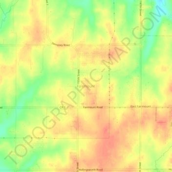
Name: Fairmount topographic map, elevation, terrain.

Location: Fairmount, Leavenworth County, Kansas, United States (39.17167 -94.95552 39.21167 -94.91552)

Average elevation: 290 m

Minimum elevation: 259 m

Maximum elevation: 308 m

Other topographic maps

Click on a map to view its topography, its elevation and its terrain.

Basehor

United States > Kansas > Leavenworth County

Average elevation: 286 m

Tonganoxie

United States > Kansas > Leavenworth County

Average elevation: 283 m

Gear up for your next adventure:

🔌Fast Charging Adapters - Quickly top up all your gear before heading back into the field
🍶Collapsible Water Bottles - Save space in your pack as you consume your water supply
👣Snake & Scrub Gaiters - Protection against spinifex, mud, and snakes while walking off-track
🔑Heavy Duty Carabiners - Secure gear to the outside of your pack for easy access
🔋Solar Power Banks - Solar chargers for outdoors

As an Amazon Associate, this site earns from qualifying purchases at no extra cost to you.