
Sirkazhi topographic map
Interactive map
Click on the map to display elevation.
About this map
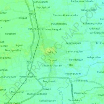
Name: Sirkazhi topographic map, elevation, terrain.
Average elevation: 5 m
Minimum elevation: 0 m
Maximum elevation: 10 m
Sirkazhi is located at 11°14′N 79°44′E / 11.23°N 79.73°E / 11.23; 79.73, on the eastern flank of the Kumbakonam-Shiyali ridge, which runs along the Kollidam River. Sirkazhi has an average elevation of 5.18 m (17.0 ft) above sea level and is located at 13 km (8.1 mi) west of Bay of Bengal. It is located 95 km (59 mi) north-east of Thanjavur, 24 km (15 mi) north of Mayiladuthurai and 20 kilometres (12 mi) south of Chidambaram.
Other topographic maps
Click on a map to view its topography, its elevation and its terrain.
Cauvery
India > Tamil Nadu > Sirkali > Alangadu
Cauvery, Alangadu, Sirkali, Mayiladuthurai District, Tamil Nadu, 609109, India
Average elevation: 7 m
Puduppattinam
India > Tamil Nadu > Sirkali
Puduppattinam, Sirkali, Mayiladuthurai district, Tamil Nadu, India
Average elevation: 3 m