Geolocate

Taal topographic map

Click on the map to display elevation.

About this map

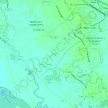
Name: Taal topographic map, elevation, terrain.

Location: Taal, Malolos, Bulacan, Central Luzon, 3015, Philippines (14.79377 120.83453 14.83377 120.87453)

Average elevation: 4 m

Minimum elevation: -1 m

Maximum elevation: 9 m

Gear up for your next adventure:

🥾Hiking Boots - Durable hiking boots for trails and rough terrain
🥾Trail Running Shoes - Shoes for trail running
👕UPF 50+ Sun Shirts - Essential protection against the harsh Australian sun during field work
🖼️Scratch-off Australia Map - Track the regions and peaks you have explored geographically
🧼Biodegradable Soap - Eco-friendly outdoor soap

As an Amazon Associate, this site earns from qualifying purchases at no extra cost to you.