Make a donation
Gear up for your next adventure:
As an Amazon Associate, this site earns from qualifying purchases at no extra cost to you.
Hessle topographic map
Click on the map to display elevation.
Make a donation
Gear up for your next adventure:
As an Amazon Associate, this site earns from qualifying purchases at no extra cost to you.
About this map
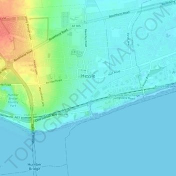
Name: Hessle topographic map, elevation, terrain.
Location: Hessle, East Riding of Yorkshire, England, United Kingdom (53.70635 -0.46743 53.73584 -0.41893)
Average elevation: 10 m
Minimum elevation: -1 m
Maximum elevation: 52 m
Make a donation
Gear up for your next adventure:
As an Amazon Associate, this site earns from qualifying purchases at no extra cost to you.
Other topographic maps
Click on a map to view its topography, its elevation and its terrain.
Flamborough Headlands
United Kingdom > England > East Riding of Yorkshire > Flamborough Headlands
Average elevation: 12 m
Make a donation
Gear up for your next adventure:
As an Amazon Associate, this site earns from qualifying purchases at no extra cost to you.
