
Pigarzos topographic map
Interactive map
Click on the map to display elevation.
About this map
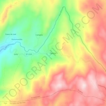
Name: Pigarzos topographic map, elevation, terrain.
Location: Pigarzos, Xesta, A Lama, Pontevedra, Galicia, España (42.36631 -8.37316 42.40631 -8.33316)
Average elevation: 845 m
Minimum elevation: 657 m
Maximum elevation: 1,010 m
Other topographic maps
Click on a map to view its topography, its elevation and its terrain.
Xesta
España > Galicia > Pontevedra > A Lama
Xesta, A Lama, Pontevedra, Galicia, España
Average elevation: 809 m