
Wolin topographic map
Interactive map
Click on the map to display elevation.
About this map
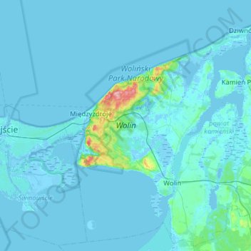
Name: Wolin topographic map, elevation, terrain.
Location: Wolin, Kamień County, West Pomeranian Voivodeship, Poland (53.80102 14.25544 54.02552 14.76828)
Average elevation: 4 m
Minimum elevation: -5 m
Maximum elevation: 112 m
Other topographic maps
Click on a map to view its topography, its elevation and its terrain.
Dziwnów
Poland > West Pomeranian Voivodeship > Kamień County
Dziwnów, gmina Dziwnów, Kamień County, West Pomeranian Voivodeship, 72-420, Poland
Average elevation: 0 m