
Grafwegen topographic map
Interactive map
Click on the map to display elevation.
About this map
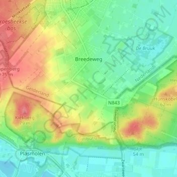
Name: Grafwegen topographic map, elevation, terrain.
Average elevation: 34 m
Minimum elevation: 6 m
Maximum elevation: 76 m
Other topographic maps
Click on a map to view its topography, its elevation and its terrain.
Colonjes
Nederland > Gelderland > Groesbeek > Breedeweg
Colonjes, Breedeweg, Groesbeek, Berg en Dal, Gelderland, Nederland, 6562 DM, Nederland
Average elevation: 43 m