
6th of October city topographic map
Interactive map
Click on the map to display elevation.
About this map
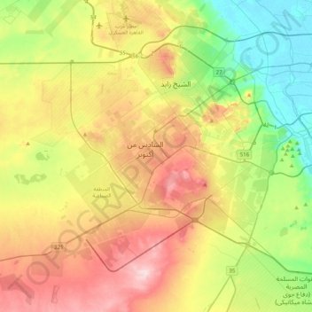
Name: 6th of October city topographic map, elevation, terrain.
Location: 6th of October city, Giza, Egypt (29.83088 30.70266 30.09705 31.10069)
Average elevation: 138 m
Minimum elevation: 14 m
Maximum elevation: 307 m
Other topographic maps
Click on a map to view its topography, its elevation and its terrain.
Black Desert
Egypt > Giza > Northern Oases
Black Desert, Al Wahat Al Bahareya, Al Farafrah Road, Northern Oases, Giza, Egypt
Average elevation: 188 m
Wadi Al-Hitan (Whale Valley)
Wadi Al-Hitan (Whale Valley), Giza, Egypt
Average elevation: 123 m
Nazlet Al Siman and Al Sisi
Nazlet Al Siman and Al Sisi, Giza, Egypt
Average elevation: 42 m
Warraq al Hadar
Egypt > Giza > Warraq al Hadar
Warraq al Hadar, Giza, 12662, Egypt
Average elevation: 21 m