Geolocate

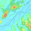
Ponta Russa topographic map

Click on the map to display elevation.

About this map

Name: Ponta Russa topographic map, elevation, terrain.

Location: Ponta Russa, Brusque, Santa Catarina, Região Sul, Brasil (-27.15113 -48.89928 -27.13666 -48.87151)

Average elevation: 135 m

Minimum elevation: 39 m

Maximum elevation: 397 m

Other topographic maps

Click on a map to view its topography, its elevation and its terrain.
Rio Itajaí-Mirim

Brasil > Santa Catarina > Brusque

Average elevation: 29 m

Gear up for your next adventure:

🧼Biodegradable Outdoor Soap - Clean gear and yourself without harming the local ecosystem
🚴Cycling Backpacks - Backpacks for cyclists
⌚Altimeter Barometer Watches - Outdoor watches with built-in sensors to track altitude changes and weather shifts
🎒Tactical Waist Packs - Quick access to your compass, phone, and snacks while walking
📚Map Reading & Navigation Guides - Master the art of interpreting topographic contours and symbols

As an Amazon Associate, this site earns from qualifying purchases at no extra cost to you.