
Make a donation
Gear up for your next adventure:
As an Amazon Associate, this site earns from qualifying purchases at no extra cost to you.
Whitworth topographic map
Click on the map to display elevation.
Make a donation
Gear up for your next adventure:
As an Amazon Associate, this site earns from qualifying purchases at no extra cost to you.
About this map
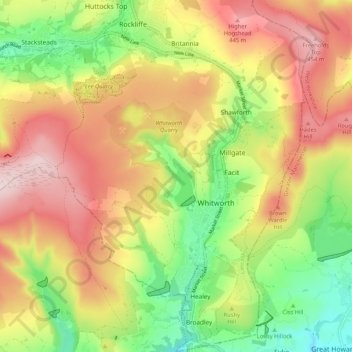
Name: Whitworth topographic map, elevation, terrain.
Average elevation: 317 m
Minimum elevation: 159 m
Maximum elevation: 477 m
Make a donation
Gear up for your next adventure:
As an Amazon Associate, this site earns from qualifying purchases at no extra cost to you.
Other topographic maps
Click on a map to view its topography, its elevation and its terrain.
Bacup
United Kingdom > England > Lancashire > Borough of Rossendale
The geology and topography of the village lent itself to urbanisation and domestic industries; primitive weavers' cottages, coal pits and stone quarries were propelled by Bacup's natural supply of water power in the Early Modern period. The adoption of the factory system, which developed into the Industrial…
Average elevation: 337 m
Haslingden Grane
United Kingdom > England > Lancashire > Borough of Rossendale > Haslingden
Average elevation: 287 m
Make a donation
Gear up for your next adventure:
As an Amazon Associate, this site earns from qualifying purchases at no extra cost to you.
Haslingden Grane
United Kingdom > England > Lancashire > Borough of Rossendale
Average elevation: 305 m
Irwell Springs
United Kingdom > England > Lancashire > Borough of Rossendale > Weir
Average elevation: 365 m
Make a donation
Gear up for your next adventure:
As an Amazon Associate, this site earns from qualifying purchases at no extra cost to you.
Clowbridge
United Kingdom > England > Lancashire > Borough of Rossendale > Habergham Eaves
Average elevation: 319 m
Whitewell Bottom
United Kingdom > England > Lancashire > Borough of Rossendale > Sagar Holme
Average elevation: 281 m
Fold Head
United Kingdom > England > Lancashire > Borough of Rossendale > Healey
Average elevation: 294 m
Make a donation
Gear up for your next adventure:
As an Amazon Associate, this site earns from qualifying purchases at no extra cost to you.
Trough Gate
United Kingdom > England > Lancashire > Borough of Rossendale > Britannia
Average elevation: 341 m
Forest Holme
United Kingdom > England > Lancashire > Borough of Rossendale > Water
Average elevation: 318 m
Nun Hills
United Kingdom > England > Lancashire > Borough of Rossendale > Stacksteads
Average elevation: 316 m
Make a donation
Gear up for your next adventure:
As an Amazon Associate, this site earns from qualifying purchases at no extra cost to you.
Cowm Reservoir
United Kingdom > England > Lancashire > Borough of Rossendale > Whitworth > Shawforth
Average elevation: 302 m
Rake Head
United Kingdom > England > Lancashire > Borough of Rossendale > Stacksteads
Average elevation: 315 m
Make a donation
Gear up for your next adventure:
As an Amazon Associate, this site earns from qualifying purchases at no extra cost to you.