
Aylesbury topographic map
Interactive map
Click on the map to display elevation.
About this map
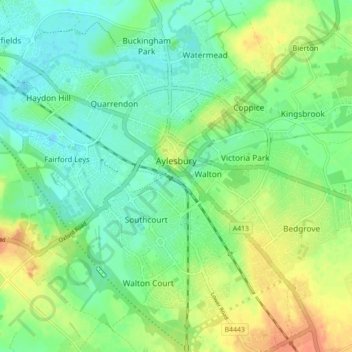
Name: Aylesbury topographic map, elevation, terrain.
Location: Aylesbury, Buckinghamshire, England, United Kingdom (51.79480 -0.86065 51.83261 -0.77269)
Average elevation: 85 m
Minimum elevation: 70 m
Maximum elevation: 107 m
Aylesbury is immediately southeast of the upper River Thame that flows past Thame to Dorchester on Thames and is partly sited on the two northernmost outcrops of Portland (lime)stone in England bisected by a small stream, Bear Brook which gives a relatively prominent position in relation to the terrain of all near, lower, fields and suburbs, which have largely slowly permeable Oxford Clay and Kimmeridge Clay soils. Elevations range from 72.5m above mean sea level to 95m AOD in contiguous parts of the town, however nearest villages range from 85m-90m to the north or from 85m to 115m on a narrow ridge to the southwest at Stone and towards the Chilterns to the southeast (Weston Turville, Stoke Mandeville and North Lee).
Other topographic maps
Click on a map to view its topography, its elevation and its terrain.
Chiltern District
United Kingdom > England > Buckinghamshire > Chalfont St Peter
Chiltern District, Chalfont St Peter, Buckinghamshire, England, United Kingdom
Average elevation: 137 m
Buckinghamshire
United Kingdom > England > Buckinghamshire
Buckinghamshire, England, United Kingdom
Average elevation: 103 m
Waddesdon
United Kingdom > England > Buckinghamshire
Waddesdon, Buckinghamshire, England, United Kingdom
Average elevation: 90 m
Asheridge
United Kingdom > England > Buckinghamshire
Asheridge, Buckinghamshire, England, HP5 2UZ, United Kingdom
Average elevation: 160 m
Buckland
United Kingdom > England > Buckinghamshire > Buckland
Buckland, Buckinghamshire, England, United Kingdom
Average elevation: 131 m
Beaconsfield
United Kingdom > England > Buckinghamshire
Beaconsfield, Beaconsfield and Chepping Wye Community Board, Buckinghamshire, England, United Kingdom
Average elevation: 103 m
Padbury
United Kingdom > England > Buckinghamshire > Padbury
Padbury, Buckinghamshire, South East England, England, United Kingdom
Average elevation: 90 m
Swanbourne
United Kingdom > England > Buckinghamshire
Swanbourne, Buckinghamshire, England, United Kingdom
Average elevation: 118 m
South Bucks
United Kingdom > England > Buckinghamshire > Beaconsfield
South Bucks, Beaconsfield, Buckinghamshire, England, United Kingdom
Average elevation: 61 m
High Wycombe
United Kingdom > England > Buckinghamshire
High Wycombe, Buckinghamshire, England, United Kingdom
Average elevation: 124 m
Bletchley
United Kingdom > England > Buckinghamshire > Milton Keynes
Bletchley, Milton Keynes, Buckinghamshire, England, MK2 2SF, United Kingdom
Average elevation: 94 m