
Thank you for supporting this site ❤️
Make a donation
Make a donation
Gear up for your next adventure:
As an Amazon Associate, this site earns from qualifying purchases at no extra cost to you.
Vibo Valentia topographic map
Click on the map to display elevation.
Thank you for supporting this site ❤️
Make a donation
Make a donation
Gear up for your next adventure:
As an Amazon Associate, this site earns from qualifying purchases at no extra cost to you.
About this map
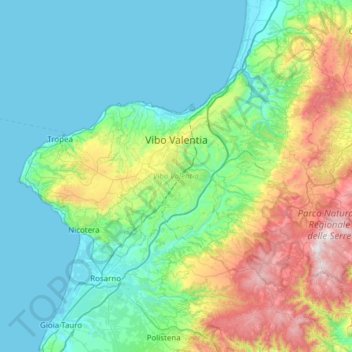
Name: Vibo Valentia topographic map, elevation, terrain.
Location: Vibo Valentia, Calabria, Italy (38.42888 15.82343 38.82442 16.43476)
Average elevation: 310 m
Minimum elevation: -1 m
Maximum elevation: 1,411 m
Thank you for supporting this site ❤️
Make a donation
Make a donation
Gear up for your next adventure:
As an Amazon Associate, this site earns from qualifying purchases at no extra cost to you.
Other topographic maps
Click on a map to view its topography, its elevation and its terrain.
Sant'Antonio
Italy > Calabria > Crotone > Isola di Capo Rizzuto > Sant'Antonio
Average elevation: 22 m