
Kiruna topographic map
Interactive map
Click on the map to display elevation.
About this map
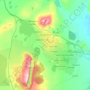
Name: Kiruna topographic map, elevation, terrain.
Location: Kiruna, Kiruna kommun, Provinz Norrbotten, 981 85, Schweden (67.80889 20.26278 67.88889 20.34278)
Average elevation: 474 m
Minimum elevation: 366 m
Maximum elevation: 726 m
Other topographic maps
Click on a map to view its topography, its elevation and its terrain.
Kiruna kommun
Kiruna kommun, Provinz Norrbotten, Schweden
Average elevation: 618 m
Abisko
Abisko, Kiruna kommun, Provinz Norrbotten, 981 07, Schweden
Average elevation: 395 m