
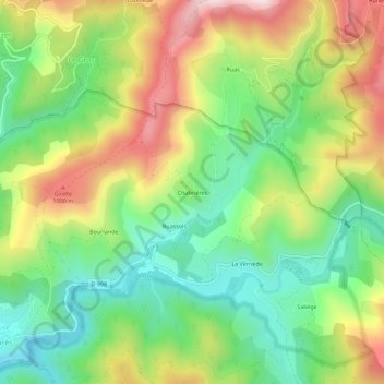
Chabrières topographic map
Interactive map
Click on the map to display elevation.
About this map
Name: Chabrières topographic map, elevation, terrain.
Average elevation: 794 m
Minimum elevation: 569 m
Maximum elevation: 1,117 m
Other topographic maps
Click on a map to view its topography, its elevation and its terrain.
Cocurès
France > Occitanie > Lozère > Bédouès-Cocurès
Cocurès, Bédouès-Cocurès, Florac, Lozère, Occitanie, France métropolitaine, 48400, France
Average elevation: 732 m
Bédouès
France > Occitanie > Lozère > Bédouès-Cocurès
Bédouès, Bédouès-Cocurès, Florac, Lozère, Occitanie, France métropolitaine, 48400, France
Average elevation: 887 m