Geolocate

Falmer topographic map

Click on the map to display elevation.

About this map

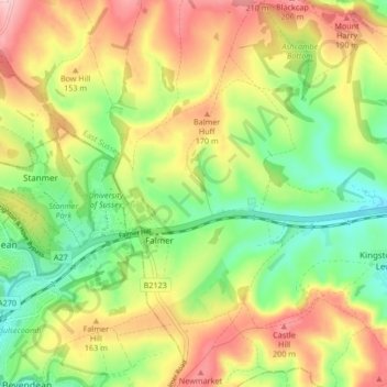
Name: Falmer topographic map, elevation, terrain.

Location: Falmer, Lewes, East Sussex, England, United Kingdom (50.84582 -0.12427 50.89172 -0.04069)

Average elevation: 116 m

Minimum elevation: 26 m

Maximum elevation: 225 m

Gear up for your next adventure:

🥾Trail Running Shoes - Shoes for trail running
📻Handheld UHF Radios - Critical communication for groups in the Australian outback
🔪Outdoor Multi-tools - Versatile tools for gear repair and survival tasks in the wilderness
Altimeter Barometer Watches - Outdoor watches with built-in sensors to track altitude changes and weather shifts
📍Handheld GPS - GPS devices for hiking and navigation

As an Amazon Associate, this site earns from qualifying purchases at no extra cost to you.