
Thank you for supporting this site ❤️
Make a donation
Make a donation
Gear up for your next adventure:
As an Amazon Associate, this site earns from qualifying purchases at no extra cost to you.
Saint-Pierre topographic map
Click on the map to display elevation.
Thank you for supporting this site ❤️
Make a donation
Make a donation
Gear up for your next adventure:
As an Amazon Associate, this site earns from qualifying purchases at no extra cost to you.
About this map
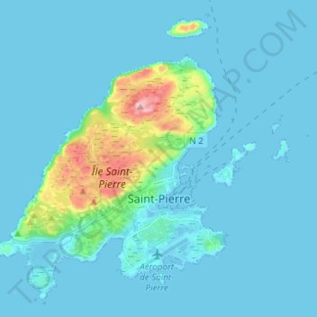
Name: Saint-Pierre topographic map, elevation, terrain.
Location: Saint-Pierre, Saint Pierre and Miquelon, 97500, France (46.74946 -56.24201 46.82660 -56.11896)
Average elevation: 20 m
Minimum elevation: -2 m
Maximum elevation: 204 m
Thank you for supporting this site ❤️
Make a donation
Make a donation
Gear up for your next adventure:
As an Amazon Associate, this site earns from qualifying purchases at no extra cost to you.