Geolocate

Linwood topographic map

Click on the map to display elevation.

About this map

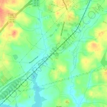
Name: Linwood topographic map, elevation, terrain.

Location: Linwood, Davidson County, North Carolina, United States (35.73069 -80.33783 35.77069 -80.29783)

Average elevation: 207 m

Minimum elevation: 187 m

Maximum elevation: 235 m

Other topographic maps

Click on a map to view its topography, its elevation and its terrain.

Denton

United States > North Carolina > Davidson County

Average elevation: 217 m

Midway

United States > North Carolina > Davidson County

Average elevation: 257 m

Denton

United States > North Carolina > Davidson County

Average elevation: 217 m

Gear up for your next adventure:

🧭Global Orienteering Compass - High-precision liquid-filled compasses for accurate map reading and navigation
📖Australian Bush Survival Books - Local knowledge on finding water and surviving the outback
👕UPF 50+ Sun Shirts - Essential protection against the harsh Australian sun during field work
🎒3L Hydration Reservoirs - Hands-free drinking to stay hydrated on steep contour climbs
🔑Heavy Duty Carabiners - Secure gear to the outside of your pack for easy access

As an Amazon Associate, this site earns from qualifying purchases at no extra cost to you.