
Make a donation
Gear up for your next adventure:
As an Amazon Associate, this site earns from qualifying purchases at no extra cost to you.
Geisingen topographic map
Click on the map to display elevation.
Make a donation
Gear up for your next adventure:
As an Amazon Associate, this site earns from qualifying purchases at no extra cost to you.
Geisingen
Geisingen liegt im Südwesten des Landkreises Tuttlingen an der Donau in 663 bis 904 Meter Höhe, am südöstlichen Rand der Baar. Die breite Hochebene der mittleren Baar verengt sich zwischen dem Wartenberg, dem nördlichsten Kegel des Hegauvulkanismus und des ihm gegenüberliegenden Höhenrückens, der „Länge“, zu einem schmalen Tal, das die Donau Richtung Osten weiterführt.
Make a donation
Gear up for your next adventure:
As an Amazon Associate, this site earns from qualifying purchases at no extra cost to you.
About this map
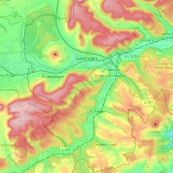
Name: Geisingen topographic map, elevation, terrain.
Average elevation: 758 m
Minimum elevation: 609 m
Maximum elevation: 940 m
Make a donation
Gear up for your next adventure:
As an Amazon Associate, this site earns from qualifying purchases at no extra cost to you.
Other topographic maps
Click on a map to view its topography, its elevation and its terrain.
Leipferdingen
Deutschland > Baden-Württemberg > Landkreis Tuttlingen > Geisingen
Average elevation: 754 m