
Sankt Johann topographic map
Interactive map
Click on the map to display elevation.
About this map
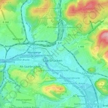
Name: Sankt Johann topographic map, elevation, terrain.
Average elevation: 233 m
Minimum elevation: 183 m
Maximum elevation: 368 m
Other topographic maps
Click on a map to view its topography, its elevation and its terrain.
Brebach-Fechingen
Allemagne > Sarre > Sarrebruck
Brebach-Fechingen, Bezirk Halberg, Sarrebruck, Regionalverband Saarbrücken, Sarre, Allemagne
Average elevation: 271 m
Vieux Sarrebruck
Allemagne > Sarre > Sarrebruck
Vieux Sarrebruck, Bezirk Mitte, Sarrebruck, Regionalverband Saarbrücken, Sarre, 66117, Allemagne
Average elevation: 234 m