Geolocate

Ciambar topographic map

Click on the map to display elevation.

About this map
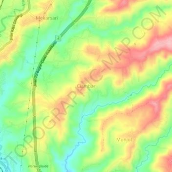
Name: Ciambar topographic map, elevation, terrain.

Location: Ciambar, Sukabumi, West Java, Java, Indonesia (-6.86457 106.75329 -6.78457 106.83329)

Average elevation: 480 m

Minimum elevation: 369 m

Maximum elevation: 670 m

Other topographic maps

Click on a map to view its topography, its elevation and its terrain.

Situ Gunung

Indonesia > West Java > Sukabumi > Kadudampit

Average elevation: 1,039 m

Cibodas

Indonesia > West Java > Sukabumi > Cimenteng

Average elevation: 260 m

Cikahuripan

Indonesia > West Java > Sukabumi

Average elevation: 110 m

Cisolok

Indonesia > West Java > Sukabumi

Average elevation: 62 m

Gear up for your next adventure:

🔋Rechargeable Batteries - Eco-friendly power for high-drain GPS units and flashlights
🪢550 Survival Paracord - Versatile cordage for gear repair and emergency lashing
📡Portable Emergency Radios - Stay informed about weather warnings and bushfire alerts
🍳Camping Cookware - Cookware sets for outdoor meals
🔋Solar Power Banks - Charge your phone and GPS using the sun while deep in the bush

As an Amazon Associate, this site earns from qualifying purchases at no extra cost to you.