
Dschabalpur topographic map
Interactive map
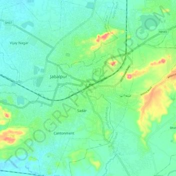
Click on the map to display elevation.
About this map
Name: Dschabalpur topographic map, elevation, terrain.
Average elevation: 408 m
Minimum elevation: 379 m
Maximum elevation: 497 m
Jabalpur liegt im Vindhyagebirge etwa 10 km nördlich des Narmada-Flusstals in einer Höhe von rund 400 m ü. d. M. Die Entfernung nach Bhopal beträgt etwa 300 km (Fahrtstrecke) in westlicher Richtung; bis nach Indore sind es insgesamt rund 500 km. Das Klima ist für indische Verhältnisse gemäßigt, Regen (ca. 1275 mm/Jahr) fällt in der Hauptsache während der sommerlichen Monsunzeit.